Presidio Tunnel Tops park, with Alcatraz Island in the background. Photo: Dicklyon, Wiki Commons
Presidio Tunnel Tops park, with Alcatraz Island in the background. Photo: Dicklyon, Wiki Commons
San Francisco has a brand-new park in Presidio Tunnel Tops, overlooking the Golden Gate Bridge and the bay. Its history is rooted in an attempt to make road traffic safer.
Nicole Sears and Alex Otani are getting married at an old Army base in San Francisco next spring. Checking out their site on a recent Tuesday afternoon, they were impressed by how beautiful the location is, especially after they stumbled across a brand-new park that overlooks the bay and the Golden Gate Bridge. “It’s just gorgeous,” Sears says. “There are views on all sides, and there are a bunch of people in our wedding party who have kids, so the park is a nice option.”
The park, which is called Presidio Tunnel Tops, opened last month, after decades of planning and debate. Its unwieldy name stems from the fact that 14 acres of dirt have been put on top of a highway tunnel taking traffic in and out of the city. “It’s interesting to have a park right above the highway, because you can hear the noise pollution at all times,” says Lia, a college student visiting the park from Palo Alto, about 35 miles to the south. “But it’s great to see people out enjoying the fresh air and nature as well.”
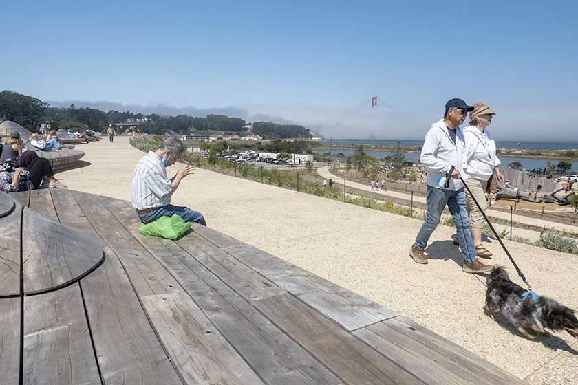
What was once a dangerous stretch of road has been redesigned in a way that opens up panoramic views of Alcatraz, Angel Island and the Transamerica Pyramid. Sculpted benches made from reclaimed wood echo the slopes of the hills across the bay. It’s possible to hear cars whooshing into the tunnel, but the park’s sonic landscape is also filled with foghorns blaring their two-tone harmonies.
Sometimes there’s a cool breeze off the Pacific Ocean; at other times, the wind is gusty enough to blow off ballcaps. The park might soak in the sunshine in the afternoon, but this time of year fog comes creeping into the bay just to the north, cloaking the bridge so that only the tops of its towers are visible over the vapor.
Even when the sun shines in the park, the Golden Gate Bridge sometimes stays shrouded in fog.
Using the bridge as a backdrop, a small group of Swedish tourists rest their rented bikes and take pictures of each other jumping off a retaining wall. A few feet away, a woman sits posing for pictures with her dog, while a pair of retirees look north over the bay, Nancy’s hand resting gently on her husband Kurt’s back. “We’re really impressed,” Kurt says. “When I saw them putting all these mounds of dirt over the tunnel, I didn’t realize they were creating this hill.”
Locals never grow weary of admiring the views. San Francisco, a city of endless hills, is surrounded by water on three sides. What has made the Golden Gate Bridge into an internationally famous landmark is not just its design and distinctive color, but its setting. The Golden Gate is a term that predates the bridge, referring to the strait where the bay spills into the Pacific Ocean, with San Francisco to the south and the stark cliffs known as the Marin Headlands to the north. “The views are incredible in all directions,” says Ian, who is visiting Lia from Boston. “I’ve driven over the bridge a few times, but it’s a lot more impressive to see from the side.”
After the bridge opened nearly 80 years ago, its main link to the city and downtown was an elevated roadway known as Doyle Drive. Every day, more than 100,000 cars used that road, which had no central divider. That made head-on collisions a recurring, sometimes fatal feature. The 1989 earthquake either brought down or made clear the dangers of elevated highways throughout San Francisco, leading to formal discussions about how to replace Doyle Drive.
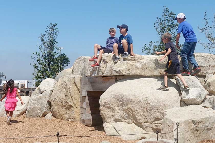
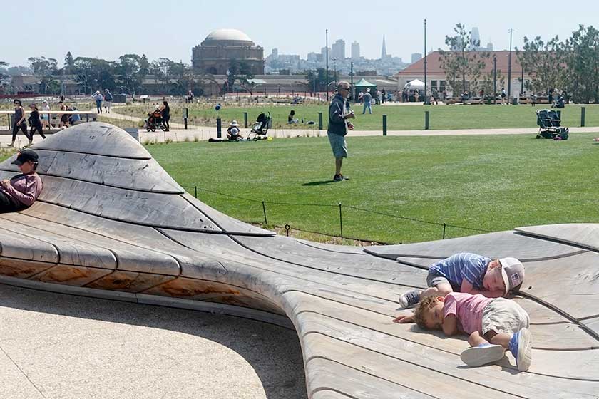
At Presidio Tunnel Tops, kids climb over retaining walls, benches, stairwells and even designated climbing areas.
A landscape architect named Michael Painter, it turned out, had the best idea. He wanted to sink the highway, turning it into a parkway that would offer better views and increased safety for drivers. It also had the potential to open up the area for recreation. Doyle Drive cut through the Presidio, which was established as a military fort by Spain back in 1776, then ceded by Mexico to the U.S. in 1848.
Given its setting, the Presidio was no ordinary military base. Occupying much of San Francisco’s northwestern corner, it’s heavily forested and boasts spectacular views. Five years after the army decided to leave the base in 1989, it was turned over to the National Park Service. Designing the new roadway required countless meetings between local, state and federal officials, with plenty of public input.
Caltrans, the state highway department, demanded hundreds of design exceptions to answer concerns raised by both engineers and lawyers. But the fact that the land itself belonged to the park service, not Caltrans, helped keep aesthetics and recreational uses a primary concern. Painter’s vision turned out to be cheaper and quicker to build than more conventional designs. Funding for the parkway was divided between Caltrans, which paid for most of the southbound lanes, and a public-private partnership that financed the northbound lanes and three of the four tunnels.
The parkway now has a number of elements painted in “international orange,” matching the color of the Golden Gate Bridge. What most visitors will notice, however, is the new landscaping topping the tunnels. About a quarter-mile west of Presidio Tunnel Tops, Battery Bluff is a smaller park that also sits atop a pair of tunnels, but offers more modest facilities. Both parks help connect not only people but Presidio watersheds with the bay.
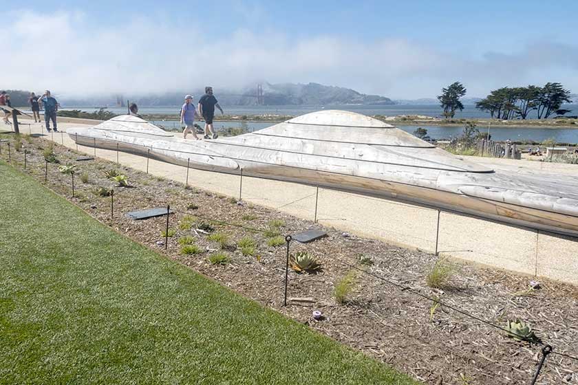
Sculpted benches, made from reclaimed wood, echo the slopes of the hills across the bay.
More than $100 million was raised to build Presidio Tunnel Tops. Its land area is not huge, but it’s cleverly cut into sections that feel distinct. Winding walkways divide areas planted with native or other drought-resistant plants from an open lawn where adults can picnic and dogs and kids can run around. Diani Ellis, a resident of suburban Daly City, says she often skates back and forth across the bridge but decided to check out the new park “to see the views.”
There’s an elaborate waterfront playground sitting at the foot of the hill created by the tunnels. Called the Outpost, it features increasingly challenging play areas for kids to explore as they grow older. There are water and sand play areas, a stand-up swing and the massive trunk of a 100-year-old oak tree for climbing over. As with the top of the park, the playground is subtly sliced into sections, enclosing the kids in pockets that allow parents to supervise from a slight distance.
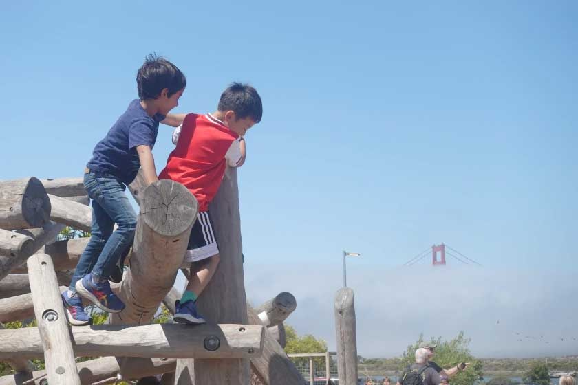
The Outpost is designed so that kids can climb and take risks with parents watching from a safe distance.
There are other attractions, including a field station where kids can pick up and examine herbs and plants and animal skulls, or just walk around carrying magnifying glasses and make like a mini Sherlock Holmes. Food trucks sell donuts, Indian curries, poke bowls, borscht and mango on a stick. There’s a glassed-in pavilion where people can escape the wind, as well as an open-air campfire circle.
Areas for grilling were one of the main points that came up through community input, says Lisa Petrie, senior public relations manager for the Presidio Trust, which oversees the park. The goal was to make the park a place that felt welcoming for people from all over the city and elsewhere, she says, not just wealthy residents of the nearby Marina District. Next door to the visitors center — once upon a time, the Army’s local drunk tank — there’s a public transit transfer station.
Presidio Tunnel Tops was designed by James Corner Field Operations, best known for designing New York’s High Line. Unlike the High Line or Atlanta’s BeltLine, both parks that also repurposed transportation infrastructure, Presidio Tunnel Tops won’t turn into a real estate play. The Presidio contains a hospital and hotels and a fitness center, but as a national park its development is strictly limited. “Star Wars” creator George Lucas helped Presidio Trust open a digital arts center, but when he wanted to put up his own art museum on Presidio land a few years ago, he was rebuffed.
Lack of neighboring development will help keep the park feeling open and attention focused outward toward the bay. Sears and Otani, the soon-to-be newlyweds, were sitting side by side at a long bench designed so that everyone enjoys the view. “It’s just really nice to see people interacting with each other, especially with what everybody’s gone through in the last couple of years with COVID,” Otani says. “It’s just nice to see kids out actually playing and adults just being able to relax.”
Designer Michael Painter wanted to connect the domed Palace of Fine Arts with the Presidio. The resulting park’s a good place for a rest.
Republished with permission from Governing Magazine, by Alan Greenblatt
Governing: The Future of States and Localities takes on the question of what state and local government looks like in a world of rapidly advancing technology. Governing is a resource for elected and appointed officials and other public leaders who are looking for smart insights and a forum to better understand and manage through this era of change.
Help Support Factkeepers!
{"id":null,"mode":"form","open_style":"in_place","currency_code":"USD","currency_symbol":"$","currency_type":"decimal","blank_flag_url":"https:\/\/factkeepers.com\/wp-content\/plugins\/tip-jar-wp\/\/assets\/images\/flags\/blank.gif","flag_sprite_url":"https:\/\/factkeepers.com\/wp-content\/plugins\/tip-jar-wp\/\/assets\/images\/flags\/flags.png","default_amount":500,"top_media_type":"none","featured_image_url":false,"featured_embed":"","header_media":null,"file_download_attachment_data":null,"recurring_options_enabled":true,"recurring_options":{"never":{"selected":true,"after_output":"One time only"},"weekly":{"selected":false,"after_output":"Every week"},"monthly":{"selected":false,"after_output":"Every month"},"yearly":{"selected":false,"after_output":"Every year"}},"strings":{"current_user_email":"","current_user_name":"","link_text":"Leave a tip","complete_payment_button_error_text":"Check info and try again","payment_verb":"Pay","payment_request_label":"Factkeepers.com","form_has_an_error":"Please check and fix the errors above","general_server_error":"Something isn't working right at the moment. Please try again.","form_title":"Help Support Factkeepers","form_subtitle":null,"currency_search_text":"Country or Currency here","other_payment_option":"Other payment option","manage_payments_button_text":"Manage your payments","thank_you_message":"Thank you for being a supporter!","payment_confirmation_title":"Factkeepers.com","receipt_title":"Your Receipt","print_receipt":"Print Receipt","email_receipt":"Email Receipt","email_receipt_sending":"Sending receipt...","email_receipt_success":"Email receipt successfully sent","email_receipt_failed":"Email receipt failed to send. Please try again.","receipt_payee":"Paid to","receipt_statement_descriptor":"This will show up on your statement as","receipt_date":"Date","receipt_transaction_id":"Transaction ID","receipt_transaction_amount":"Amount","refund_payer":"Refund from","login":"Log in to manage your payments","manage_payments":"Manage Payments","transactions_title":"Your Transactions","transaction_title":"Transaction Receipt","transaction_period":"Plan Period","arrangements_title":"Your Plans","arrangement_title":"Manage Plan","arrangement_details":"Plan Details","arrangement_id_title":"Plan ID","arrangement_payment_method_title":"Payment Method","arrangement_amount_title":"Plan Amount","arrangement_renewal_title":"Next renewal date","arrangement_action_cancel":"Cancel Plan","arrangement_action_cant_cancel":"Cancelling is currently not available.","arrangement_action_cancel_double":"Are you sure you'd like to cancel?","arrangement_cancelling":"Cancelling Plan...","arrangement_cancelled":"Plan Cancelled","arrangement_failed_to_cancel":"Failed to cancel plan","back_to_plans":"\u2190 Back to Plans","update_payment_method_verb":"Update","sca_auth_description":"Your have a pending renewal payment which requires authorization.","sca_auth_verb":"Authorize renewal payment","sca_authing_verb":"Authorizing payment","sca_authed_verb":"Payment successfully authorized!","sca_auth_failed":"Unable to authorize! Please try again.","login_button_text":"Log in","login_form_has_an_error":"Please check and fix the errors above","uppercase_search":"Search","lowercase_search":"search","uppercase_page":"Page","lowercase_page":"page","uppercase_items":"Items","lowercase_items":"items","uppercase_per":"Per","lowercase_per":"per","uppercase_of":"Of","lowercase_of":"of","back":"Back to plans","zip_code_placeholder":"Zip\/Postal Code","download_file_button_text":"Download File","input_field_instructions":{"tip_amount":{"placeholder_text":"How much would you like to donate? You can change this amount to anything you would like.","initial":{"instruction_type":"normal","instruction_message":"How much would you like to donate? You can change this amount to anything you would like."},"empty":{"instruction_type":"error","instruction_message":"How much would you like to donate? You can change this amount to anything you would like."},"invalid_curency":{"instruction_type":"error","instruction_message":"How much would you like to donate? You can change this amount to anything you would like."}},"recurring":{"placeholder_text":"Recurring","initial":{"instruction_type":"normal","instruction_message":"How often would you like to donate this?"},"success":{"instruction_type":"success","instruction_message":"How often would you like to donate this?"},"empty":{"instruction_type":"error","instruction_message":"How often would you like to donate this?"}},"name":{"placeholder_text":"Name on Credit Card","initial":{"instruction_type":"normal","instruction_message":"Enter the name on your card."},"success":{"instruction_type":"success","instruction_message":"Enter the name on your card."},"empty":{"instruction_type":"error","instruction_message":"Please enter the name on your card."}},"privacy_policy":{"terms_title":"Terms and conditions","terms_body":null,"terms_show_text":"View Terms","terms_hide_text":"Hide Terms","initial":{"instruction_type":"normal","instruction_message":"I agree to the terms."},"unchecked":{"instruction_type":"error","instruction_message":"Please agree to the terms."},"checked":{"instruction_type":"success","instruction_message":"I agree to the terms."}},"email":{"placeholder_text":"Your email address","initial":{"instruction_type":"normal","instruction_message":"Enter your email address"},"success":{"instruction_type":"success","instruction_message":"Enter your email address"},"blank":{"instruction_type":"error","instruction_message":"Enter your email address"},"not_an_email_address":{"instruction_type":"error","instruction_message":"Make sure you have entered a valid email address"}},"note_with_tip":{"placeholder_text":"Your note here...","initial":{"instruction_type":"normal","instruction_message":"Attach a note to your tip (optional)"},"empty":{"instruction_type":"normal","instruction_message":"Attach a note to your tip (optional)"},"not_empty_initial":{"instruction_type":"normal","instruction_message":"Attach a note to your tip (optional)"},"saving":{"instruction_type":"normal","instruction_message":"Saving note..."},"success":{"instruction_type":"success","instruction_message":"Note successfully saved!"},"error":{"instruction_type":"error","instruction_message":"Unable to save note note at this time. Please try again."}},"email_for_login_code":{"placeholder_text":"Your email address","initial":{"instruction_type":"normal","instruction_message":"Enter your email to log in."},"success":{"instruction_type":"success","instruction_message":"Enter your email to log in."},"blank":{"instruction_type":"error","instruction_message":"Enter your email to log in."},"empty":{"instruction_type":"error","instruction_message":"Enter your email to log in."}},"login_code":{"initial":{"instruction_type":"normal","instruction_message":"Check your email and enter the login code."},"success":{"instruction_type":"success","instruction_message":"Check your email and enter the login code."},"blank":{"instruction_type":"error","instruction_message":"Check your email and enter the login code."},"empty":{"instruction_type":"error","instruction_message":"Check your email and enter the login code."}},"stripe_all_in_one":{"initial":{"instruction_type":"normal","instruction_message":"Enter your credit card details here."},"empty":{"instruction_type":"error","instruction_message":"Enter your credit card details here."},"success":{"instruction_type":"normal","instruction_message":"Enter your credit card details here."},"invalid_number":{"instruction_type":"error","instruction_message":"The card number is not a valid credit card number."},"invalid_expiry_month":{"instruction_type":"error","instruction_message":"The card's expiration month is invalid."},"invalid_expiry_year":{"instruction_type":"error","instruction_message":"The card's expiration year is invalid."},"invalid_cvc":{"instruction_type":"error","instruction_message":"The card's security code is invalid."},"incorrect_number":{"instruction_type":"error","instruction_message":"The card number is incorrect."},"incomplete_number":{"instruction_type":"error","instruction_message":"The card number is incomplete."},"incomplete_cvc":{"instruction_type":"error","instruction_message":"The card's security code is incomplete."},"incomplete_expiry":{"instruction_type":"error","instruction_message":"The card's expiration date is incomplete."},"incomplete_zip":{"instruction_type":"error","instruction_message":"The card's zip code is incomplete."},"expired_card":{"instruction_type":"error","instruction_message":"The card has expired."},"incorrect_cvc":{"instruction_type":"error","instruction_message":"The card's security code is incorrect."},"incorrect_zip":{"instruction_type":"error","instruction_message":"The card's zip code failed validation."},"invalid_expiry_year_past":{"instruction_type":"error","instruction_message":"The card's expiration year is in the past"},"card_declined":{"instruction_type":"error","instruction_message":"The card was declined."},"missing":{"instruction_type":"error","instruction_message":"There is no card on a customer that is being charged."},"processing_error":{"instruction_type":"error","instruction_message":"An error occurred while processing the card."},"invalid_request_error":{"instruction_type":"error","instruction_message":"Unable to process this payment, please try again or use alternative method."},"invalid_sofort_country":{"instruction_type":"error","instruction_message":"The billing country is not accepted by SOFORT. Please try another country."}}}},"fetched_oembed_html":false}
{"date_format":"F j, Y","time_format":"g:i a","wordpress_permalink_only":"https:\/\/factkeepers.com\/presidio-tunnel-tops-how-san-francisco-turned-a-dangerous-highway-into-a-kids-paradise\/","all_default_visual_states":"inherit","modal_visual_state":false,"user_is_logged_in":false,"stripe_api_key":"pk_live_40P3DgGDAHEP1QtJ0nOU4nms5JYHI8GbQ05dYiB1S8OPP5oMSIpOCCeeIawOyeW6bWDkDMWdUeggbhxOQTSA6aedu00ROAbhXBd","stripe_account_country_code":"US","setup_link":"https:\/\/factkeepers.com\/wp-admin\/admin.php?page=tip-jar-wp&mpwpadmin1=welcome&mpwpadmin_lightbox=do_wizard_health_check","close_button_url":"https:\/\/factkeepers.com\/wp-content\/plugins\/tip-jar-wp\/\/assets\/images\/closebtn.png"}